


Naviator

Naviator의 설명
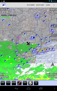
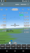
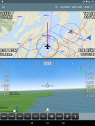
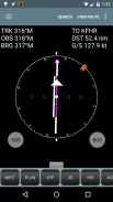
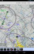
Naviator is a moving map GPS application made by pilots, for pilots.!!! IMPORTANT !!!This is a 30 day FREE TRIAL of Naviator. Please see the "Subscription Information" section below for more details.FEATURES:• Moving map with airspace, airports, radio navigation aids, airway intersections, TFRs
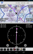
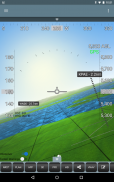
• Support for ADS-B receivers including theDual XGPS 170,iLevilandSkyGuardTWX• Track-up map display
• All navigational data is downloaded to your device - no internet connection is required while you are flying
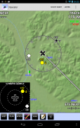
• Global terrain database with terrain warnings
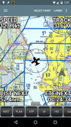
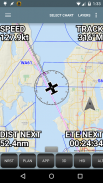
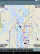
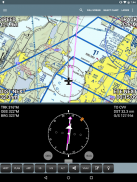
• Global high-detail VFR base map
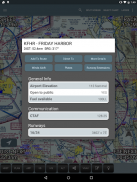
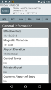
• World-wide airports/facilities database containing over 53,000 airports and navaids (updated on a 56 day cycle)
• Easy "rubber band" flight planning
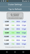
• Global Forecast Engine provides winds aloft anywhere on the planet up to 54,000 feet
• Integrates with ADS-B or theZaon XRXfor traffic display
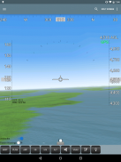
• Integrates with Microsoft Flight Simulator
• Integrates with X-Plane using the "X-Plane to GPS" app (https://play.google.com/store/apps/details?id=com.appropel.xplanegps)
• Lockheed Martin AFSS Integration - File flight plans directly with Lockheed Martin
• DUATS integration - get a briefing and file a flight plan from right inside the app
• Weather information (METAR/TAF/NEXRAD/SIGMET/AIRMET)
• Victor Airways and Jet Routes
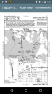
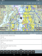
• FAA VFR sectional charts
• FAA VFR terminal area charts
• FAA IFR enroute charts
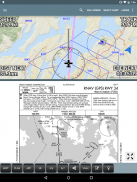
• FAA approach plates and airport diagrams (optionally geo-referenced)
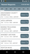
• User defined waypoints
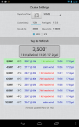
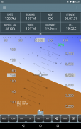
• Vertical navigation (VNAV) calculator
• TFR areas are displayed on the map. Tap within a TFR area to see affected altitudes and other details
• Canadian data including airspace, airports, navaids, terrain and weather
• GPS track recording - export to GPX file format
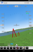
• View your recorded flights in 3D with Google Earth
• NMEA output - Naviator can drive your aircraft's autopilot
• "Bring Your Own Charts" - you can import custom maps and charts into the app. See our forum for more details.
Our support forum is located athttp://forum.naviatorapp.com/SUBSCRIPTION INFORMATION:Subscriptions provide access to all software updates, FAA Sectional charts, FAA Terminal Area charts, FAA IFR Enroute charts, FAA approach plates, weather updates, TFR updates, and the Naviator world-wide airports and facilities database.PRICING:Naviator is free of charge for the first 30 days of use. After this trial period, the following items may be purchased:
(a) 30 Day Chart Subscription - $4.99 USD
Enables the download and use of geo-referenced charts for 30 days.
(b) 1 Year Chart Subscription - $34.99 USD
*** 30% OFF SALE - REG. PRICE $49.99 ***
Enables the download and use of geo-referenced charts for one year.*The purchase of a one year subscription includes item (c) in the purchase price.(c) Unlock Naviator - $14.99 USD
This one-time charge permanently unlocks all features of Naviator, except FAA approach plates, sectionals, TACs, IFR enroute charts, TFR updates and the "BYOC" feature.Includes database updates, weather updates, high-detail VFR base mapItems (a) and (b) include VFR sectional charts, terminal area charts, IFR enroute HI/LO charts, approach plates, database updates, weather updates, TFR updates, and the high-detail VFR base map.Naviator는 조종사, 조종사에 의해 움직이는지도의 GPS 응용 프로그램입니다.
의! 중요!
이 Naviator의 30 일 무료로 이용하실 수 있습니다. 더 자세한 내용은 아래의 "가입 정보"절을 참조하십시오.
의특징 :
• 영공으로지도를 이동, 공항, 무선 항행 원조,기도 교차로, TFRs
•의듀얼 XGPS (170) 에서iLevil 나SkyGuardTWX 을 포함하여 ADS-B 수신기 지원
• 트랙까지지도 표시
• 모든 탐색 데이터는 장치에 다운로드됩니다 - 당신이 비행하는 동안 인터넷에 연결이 필요하지 않습니다
• 지형 경고 글로벌 지형 데이터베이스
• 글로벌 높은 세부 VFR 기본지도
• (56 일주기 갱신) 53,000 공항과 navaids을 포함 전 세계적으로 공항 / 시설 데이터베이스
• 간편한 "고무 밴드"비행 계획
• 글로벌 예측 엔진은 위에 어디 행성에 바람을 제공하는 최대 54,000피트
• ADS-B 또는의Zaon XRX 교통 디스플레이와 통합
• 마이크로 소프트 비행 시뮬레이터와 통합
•은 "X-평면 GPS에"응용 프로그램을 사용하여 X-평면과 통합 (https://play.google.com/store/apps/details?id=com.appropel.xplanegps)
• 록히드 마틴 AFSS 통합 - 파일 비행 록히드 마틴과 직접 계획
• DUATS 통합 - 브리핑을하고 바로 응용 프로그램 내부에서 비행 계획을 제출
• 날씨 정보 (METAR / TAF / NEXRAD / 악기상 / AIRMET)
• 빅터 항공과 제트 경로
• FAA VFR 단면 차트
• FAA VFR 터미널 영역 차트
• FAA IFR 도중에 차트
• FAA 접근 플레이트 및 공항 다이어그램 (선택적 지리적 참조)
• 사용자 정의 중간
• 수직 탐색 (VNAV) 계산기
• TFR 지역이지도에 표시됩니다. 영향을받는 고도 및 기타 세부 사항을 확인하기 위해 TFR 지역 내 탭
• 영공, 공항, navaids, 지형과 날씨 등의 캐나다 데이터
• GPS 트랙 기록 - GPX 파일 형식으로 내보내기
• 구글 어스와 3D로 촬영 한 항공편보기
• NMEA 출력 - Naviator이 항공기의 자동 조종 장치를 구동 할 수
• "자신의 차트를 가져와"- 당신은 응용 프로그램에 사용자 지정지도 및 차트를 가져올 수 있습니다. 자세한 내용은 포럼을 참조하십시오.
우리의 지원 포럼은http://forum.naviatorapp.com/에위치
의가입 정보 :
구독은 모든 소프트웨어 업데이트, FAA 단면 차트, FAA 터미널 영역 차트, FAA IFR 도중에 차트, FAA 접근 플레이트, 날씨 업데이트, TFR 업데이트 및 Naviator의 전세계 공항 시설 데이터베이스에 대한 액세스를 제공합니다.다운로드 가격 설정 :
Naviator 사용의 처음 30 일 동안 무료로 제공됩니다. 이 시험 기간 후에, 다음 항목은 구입하실 수 있습니다 :
() 30 일 차트 구독 - $ 4.99 USD
30 일 지리 정보 차트의 다운로드 및 사용을 가능하게합니다.
(B) 1 년 차트 구독 - $ 34.99 USD
*** 30 % OFF 세일 - REG. *** $ 49.99 판매 가격
일년 지리 정보 차트의 다운로드 및 사용을 가능하게합니다.* 1 년 정기 구독의 구입은 구입 가격에 항목 (C)를 포함한다.
(C) 잠금 해제 Naviator - $ 14.99 USD
이 한 시간 요금은 영구적으로 FAA 접근 플레이트, sectionals, 공군, IFR 도중에 차트, TFR 업데이트 및 "BYOC"기능을 제외하고, Naviator의 모든 기능을 잠금 해제합니다.데이터베이스 업데이트, 날씨 정보, 높은 세부 VFR의 기본지도 를 포함
항목 (a)와 (b) VFR의 단면 차트, 터미널 영역 차트, IFR 도중에 HI / LO 차트, 접근 접시, 데이터베이스 업데이트, 날씨 업데이트, TFR 업데이트 및 높은 세부 VFR의 기본지도 (가) 있습니다.
Naviator - 버전 4.2.2
(21-12-2020)
Naviator - APK 정보
APK 버전: 4.2.2패키지: com.onetwentythree.skynavNaviator의 최신 버전
다른 버전들


동일 카테고리의 앱


